

With our suite of Primary Care data visualisations tools you can analyse workforce and practice coverage, assess the impact of practice closures and mergers, monitor patient access rates to services and plan staff work rotas.
Helping you see the bigger picture and make the right decisions
- Visualise challenges around equity of access and patient choice - location-based solutions that layer population and health data will help to ensure that your local populations have equal and fair access to your services.
- Improve your decision-making – using geospatial technologies to inform your solutions by unlocking hidden patterns and trends within national and local populations, combining multiple data sets, and providing valuable insight.
- Operational efficiencies for you, your team and your PCNs – easy to use, powerful technology saving time and improving accuracy.
- Easy to understand data visualisations – Speeds up the process, is more accessible and enables you to gain buy-in for your solutions - with compelling data visualisations and impressive data layering.
Case study: Ensuring patients from a closing GP practice get fair treatment
Pharmacy, ophthalmic and dentistry (POD) services
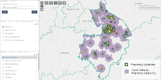
Image: Dashboard application showing ICB boundaries, pharmacy locations and walking travel zones to pharmacies
Building on the work we developed in collaboration with the NHS England national team, we can support delegated functions with a powerful tool that provides an interactive visualisation of POD data.
Building on the work we developed in collaboration with the NHS England national team, we can support delegated functions with a powerful tool that provides an interactive visualisation of POD data.
How we can help
1
Service provider locations (pharmacies by type, opticians, dentists)
2
Contextual reference datasets (healthcare boundaries, population demographics, travel accessibility to services)
3
Pharmacy-controlled localities, and rurality reviews
4
Pharmacy market entry and application maps
5
Bespoke analysis e.g. bank holiday rotas showing coverage status – working with local data to create a bespoke solution
6
Tier 2 dental service providers and referral data
7
Data relating to special schools
Dispensing list validation (DLV)

Image: Pharmacist speaking with a patient
An end-to-end service to support the annual validation of the dispensing patient register in compliance with NHS England pharmacy policy.
An end-to-end service to support the annual validation of the dispensing patient register in compliance with NHS England pharmacy policy.
How we can help
Recognising the need to minimise the impact of bureaucracy on GP practices our service provides the following support:
1
Mapping of patient address with dispensing boundary, identifying those beyond the boundary
2
Working with the GP practice to identify the patients and agree communication approach
3
Issuing letters to all impacted patients informing them of the change
4
Provision of support with patient queries
5
Online tools are made available for 12 months following validation exercise to ensure all new patients receive the appropriate dispensing rights
Workforce analysis and reporting
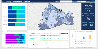
Image: Dashboard showing graphs that summarise staffing levels by workforce type, surrounding a central map with coloured areas based on their staffing levels
How we can help
Our geospatial tool can support you with workforce analysis and planning, and to evaluate existing and future staffing needs.
1
Interactive visualisation of National GP workforce data coupled with local intelligence
2
When coupled with demographic and population health data this tool can inform current and future workforce requirements
3
Enables visualisation of local progress against national targets such as GP recruitment and retention, Additional Roles Reimbursement Scheme (ARRS) roles, GP trainees etc
GP practice list dispersal
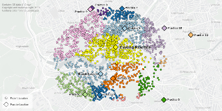
Image: Spread of registered patients on a map showing their nearest alternative GP practice by walking time
Helps you understand the impact of practice closures on the sustainability of neighbouring GP practices, and provide intelligence to inform options appraisals and support recommendations to Health Overview and Scrutiny Committee (HOSC).
Helps you understand the impact of practice closures on the sustainability of neighbouring GP practices, and provide intelligence to inform options appraisals and support recommendations to Health Overview and Scrutiny Committee (HOSC).
How we can help
1
Provide time-efficient, location-based analyses that inform a dispersal plan for patients
2
Ensure equity of patient access and fair and robust decision-making, using journey time methodology and patient preference surveys
3
Minimise family disruption and protect vulnerable populations through patient preference surveys
4
Sophisticated workflows ready to deploy, allocating patients to neighbouring practices (considering patient preferences, travel time, and practice capacities)
5
Secure and safe handling of NHS Patient Identifiable Data (PID) using patient records from either Patient Demographic Service or directly from the closing practice
6
Support with Information Governance, such as completion of a Data Protection Impact Assessment (DPIA)
Geospatial consultancy services
We're here to help you tackle your biggest challenges and solve your location-based problems.
Our geospatial consultancy team will work alongside you (and with other blended teams across NHS SCW where required) to deliver bespoke solutions and tailored support.- Practice closures and mergers (including impact analysis for populations and other service providers)
- Analysis of patient movement between GP practices, supporting closures, mergers or new surgeries opening, and re-allocation of patients to practices
- Practice boundary reviews; analysis of overall practice coverage and gaps across a system area
- Estates mapping and Carbon Net Zero analysis
- Primary Care Network (PCN) or other neighbourhood/locality mapping
- Wall-maps or posters for events or offices (printed up to A0 size)
- Facilitating workshops using geospatial visualisations to support decision-makers.
Testimonials and comments on our work

Geospatial solutions to improve cancer screening uptake
Are you looking for a solution to help target and promote effective patient engagement to improve cancer screening uptake? Our geospatial consultants create location-based solutions that layer populat...

Geospatial services
Our team of Geographic Information System (GIS) specialists provide geospatial services to support ICBs, NHSE and numerous NHS Hospital Trusts and other organisations. We often work collaboratively wi...

Supporting primary care
Our team is here to engage in transformational conversations, apply our hands-on experience, and work with you to identify opportunities and solutions to address the challenges facing primary care.
...
Contact the team
If you'd like to find out more about how our Geospatial team can help you, please complete the form and we'll be in touch very soon.